METAR & TAF PACD
Current METAR
Observed 20:53Z
PACD 282053Z 26014KT 8SM FEW010 BKN043 OVC055 09/07 A3019
- Wind
- 260° @ 14 kt
- Visibility
- 8 SM
- Temp / Dew
- 9°C / 7°C
- Altimeter
- 30.19 inHg
- Clouds
- OVC
- Density alt
- -931 ft
- Ceiling
- 4,300 ft AGL
- Rules
- VFR
Airport info & contacts
Manager on record, flight service, ARTCC, attendance schedule and pattern altitude — published by the FAA and refreshed every 28 days.
Location
- From city
- 0 NM N
- VFR sectional
- COLD BAY
- ARTCC
- ZAN · ANCHORAGE
- NOTAM facility
- CDB (NOTAM-D)
Airport manager
- Name
- RUSSELL RUTA
- Phone
- 907-532-5000
- Address
- BOX 97, COLD BAY AK 99571
Flight service · Hours
- FSS CDB
- COLD BAY907-532-24661-800-478-7250
- Attendance
- MON - SAT · 0700 - 1800
Frequencies
Tap any row to copy the frequency to your clipboard.
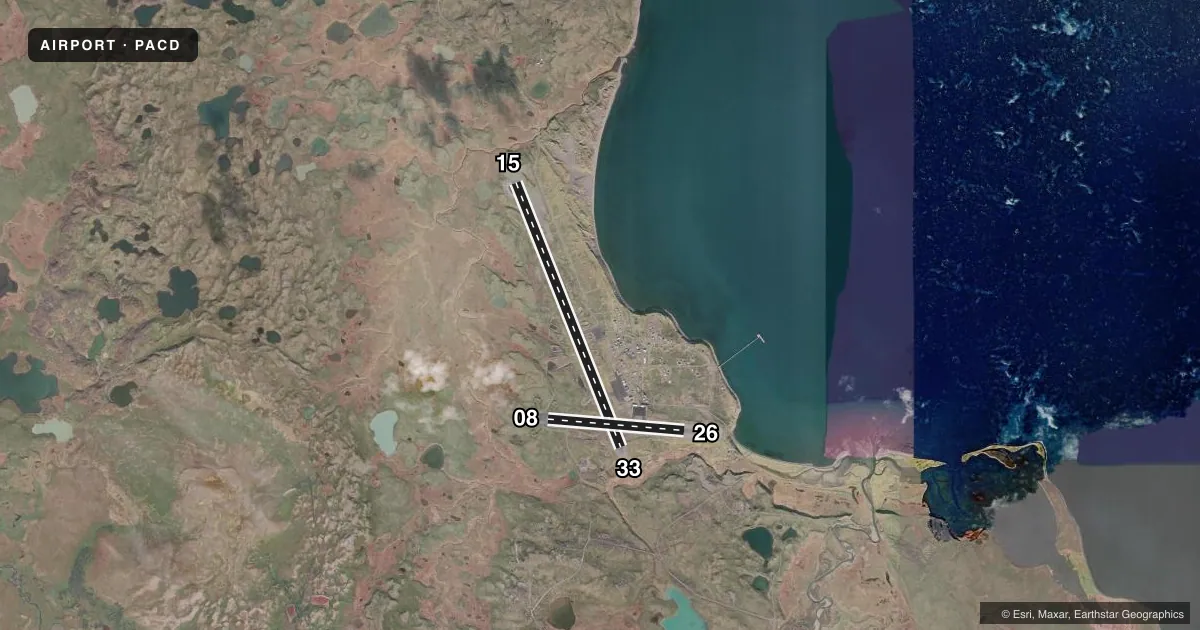
Runways & pattern
Full pagePattern entry · RWY 26
RIGHT TRAFFIC| Runway | Heading (°M) | Length | Surface | Traffic |
|---|---|---|---|---|
| 15/33 | 146° / 326° | 10,179 ft | ASPH | 33 R |
| 08/26Favored | 83° / 263° | 4,900 ft | ASPH | 26 R |
Runway end performance
| End | TORA | TODA | ASDA | LDA | VGSI | Approach lights | Obstruction |
|---|---|---|---|---|---|---|---|
| 15 | 10,179' | 10,179' | 10,179' | 10,179' | — | MALSR | — |
| 33 | 10,179' | 10,179' | 10,179' | 10,179' | PAPI 4-box left(3°) | — | — |
| 08 | 4,900' | 4,900' | 4,900' | 4,900' | PAPI 4-box left(3.5°) | — | — |
| 26 | 4,900' | 4,900' | 4,900' | 4,900' | PAPI 4-box left(3°) | — | — |
Declared distances in feet. TORA = takeoff run available, TODA = takeoff distance, ASDA = accelerate-stop, LDA = landing distance.
Airport sketch
Runways drawn to scale from FAA survey coordinates, rendered over satellite imagery. Not for navigation.
Approaches & charts
ILS · 1
Services on the field
Fuel grades, oxygen, maintenance, ramp storage and lighting — as declared to the FAA by the airport operator.
Fuel & services
- Fuel
- 100LLA
- Other services
- CARGO
Ramp & ground
- Transient storage
- Tie-down
- Landing fee
- No fee published
- Customs
- Not available
- Lighting schedule
- SEE RMK
- Beacon schedule
- SEE RMK
- Beacon
- White / Green (civil land)(WG)
- Wind indicator
- Yes
- Segmented circle
- Yes
Fuel & FBOs
Cheapest 100LL and Jet A on the field and nearby. Always confirm with the FBO before taxi.
Airport notes
Surface conditions, obstructions, local procedures, lighting outages and other notes published with each FAA cycle.
General notes
- SNOW, ICE REMOVAL & ARPT HAZ RPRTG DURG DUTY HR UNLESS PRIOR ARNGMT IN WRITING - AMGR.
- BIRDS INVOF ARPT.
- LOCKED WHEEL NA.
- CUST UNAVBL. FOREIGN RFLG ARR 24-48 HR WRITTEN PPR - FAX 907-271-2684 OR 907-271-2686.
- UNLGTD TWR 0.4 NM N, 0.9 NM S & 4.8 NM NW.
- PAEW ON RWYS.
- ARPT SAND LRGR GRADE THAN FAA RCMDD/SEE AC150/5200-30.
- WX CAMERA AVBL - HTTPS://WEATHERCAMS.FAA.GOV
- DEICING & FUEL M-F 0800-1700 - 907-532-2467; AFT HR PPR & FEE - 907-532-7055.
Lighting notes
- PHOTOCELL OPS.
- ATCVT MALSR RWY 15; PAPI RWY 08, 26 & 33; HIRL RWY 08/26 & 15/33 - CTAF.
Runway surface & condition
- 08/26PCR VALUE: 620/F/B/X/T
- 15/33PCR VALUE: 620/F/B/X/T
Approach & departure obstructions
- 08UNUSBL BYD 5 DEGS RIGHT OF CNTRLN.
Other notes
- CLSD TO ACR OPS MORE THAN 30 PAX SEATS EXC WRITTEN PPR - AMGR BOX 97 COLD BAY AK 99571. ARFF AVBL FOR PART 121 ETOPS ACR WITH 30 MIN NOTICE.
VFR map & nearby airports
VFR sectional. Tap any ICAO chip to open that airport.
Key facts · PACD
Answer card- ICAO
- PACD
- Name
- COLD BAY
- Location
- COLD BAY, ALASKA
- Elevation
- 99.5 ft MSL
- Traffic pattern altitude
- 1,099.5 ft MSL (1,000 AGL)
- Control tower
- Non-towered (use CTAF)
- Total runways
- 2
- Longest runway
- 15/33 · 10,179 ft
- Published ILS approaches
- 1
- Published frequencies
- 1
- Magnetic variation
- 12°
- Current flight rules
- VFR
- Current wind
- 260° at 14 kt
- Favored runway now
- RWY 26
Cold Bay Airport sits in Cold Bay, Alaska. Field elevation is 99.5 ft MSL. The airport has two asphalt runways. The longest is runway 15/33 at 10,179 ft. Runway 08/26 is 4,900 ft.
This is an uncontrolled field. CTAF is 123.6. Pattern altitude is not published. Use the standard 1,000 ft AGL pattern for light piston traffic unless local conditions or published guidance say otherwise. The airport has one ILS approach to runway 15. Runway 15 also has medium intensity approach lighting with runway alignment indicator lights. Runways 08, 26 and 33 have PAPI. Runways 08/26 and 15/33 have high intensity runway lights.
Frosty Fuels is on the field. It carries AVGAS 100LL, JET A and MOGAS. Deicing and fuel services are listed Monday through Friday from 0800 to 1700 local. After-hours service is by prior permission. Cold Bay is a remote Alaska field, so plan for weather, snow and ice. The remarks also note that runway 08 has a VASI limitation more than 5 degrees right of centerline. Customs is unavailable. Foreign refueling arrivals need written prior permission in advance. Check the current FAA Chart Supplement and call the airport operator or Frosty Fuels before you go.