METAR & TAF 1N1
1N1 does not publish a METAR.
Showing the nearest reporting station: KABQ (ALBUQUERQUE INTL SUNPORT) · 22.1 NM away. Conditions at 1N1 may differ.
METAR · KABQ
Observed 01:52Z
KABQ 120152Z 36006KT 10SM FEW140 SCT250 32/M00 A2997 RMK AO2 SLP048 T03220000 $
- Wind
- 360° @ 6 kt
- Visibility
- 10 SM
- Temp / Dew
- 32°C / 0°C
- Altimeter
- 29.97 inHg
- Clouds
- SCT
- Density alt
- 10,119 ft
- Ceiling
- Unlimited
- Rules
- VFR
Airport info & contacts
Manager on record, flight service, ARTCC, attendance schedule and pattern altitude — published by the FAA and refreshed every 28 days.
Location
- From city
- 2 NM NE
- VFR sectional
- ALBUQUERQUE
- ARTCC
- ZAB · ALBUQUERQUE
- NOTAM facility
- ABQ (NOTAM-D)
Airport manager
- Name
- KELLY TANIS
- Phone
- 505-280-3665
- Address
- 71 RAINBOW ROAD, EDGEWOOD NM 87015
Flight service · Hours
- FSS ABQ
- ALBUQUERQUE1-800-WX-BRIEF
- Attendance
- Unattended
Frequencies
Tap any row to copy the frequency to your clipboard.
Runways & pattern
Full pagePattern entry · RWY 09
LEFT TRAFFICRunway end performance
| End | TORA | TODA | ASDA | LDA | VGSI | Approach lights | Obstruction |
|---|---|---|---|---|---|---|---|
| 09 | — | — | — | — | — | — | 14', bldg, 400' from thr, 140' R of cntrln, slope 14 |
Declared distances in feet. TORA = takeoff run available, TODA = takeoff distance, ASDA = accelerate-stop, LDA = landing distance.
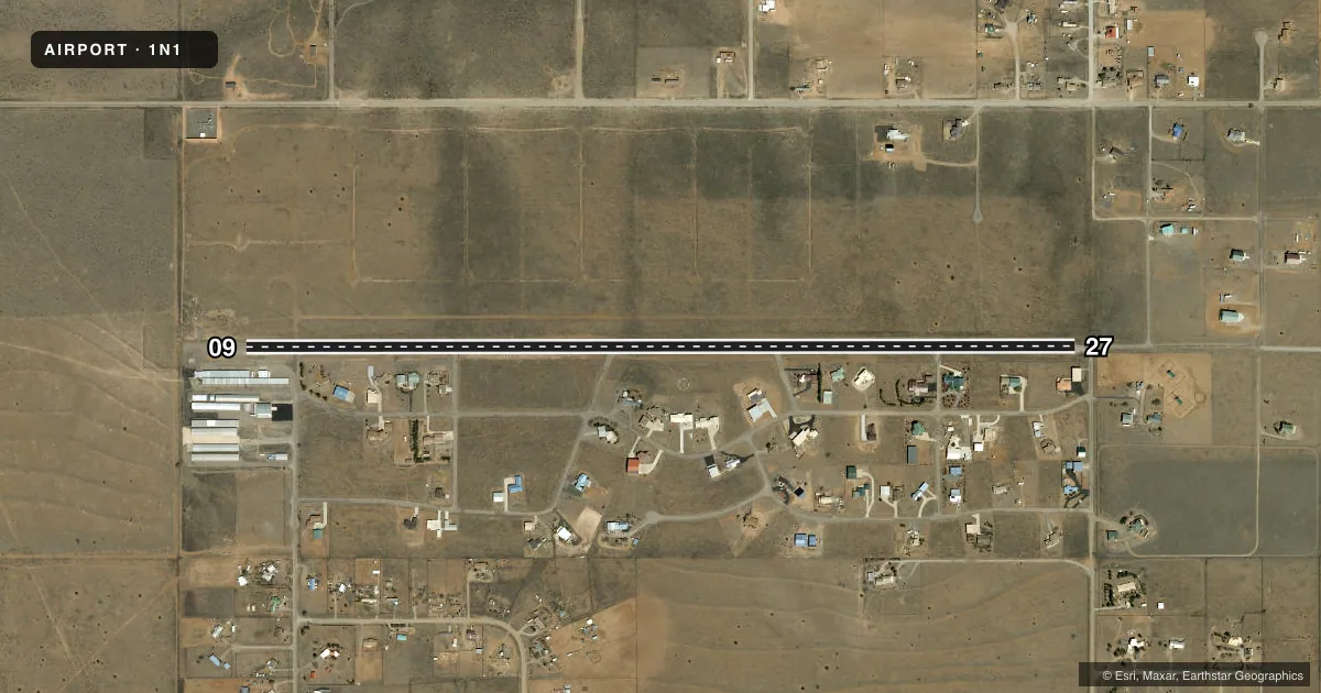
Airport sketch
Runways drawn to scale from FAA survey coordinates, rendered over satellite imagery. Not for navigation.
Approaches & charts
Services on the field
Fuel grades, oxygen, maintenance, ramp storage and lighting — as declared to the FAA by the airport operator.
Fuel & services
- Fuel
- 100LL
- Airframe repair
- Major
- Power plant repair
- Major
Ramp & ground
- Transient storage
- Tie-down
- Landing fee
- No fee published
- Lighting schedule
- SEE RMK
- Beacon schedule
- SEE RMK
- Beacon
- White / Green (civil land)(WG)
- Wind indicator
- Lighted
Fuel & FBOs
Cheapest 100LL and Jet A on the field and nearby. Always confirm with the FBO before taxi.
Airport notes
Surface conditions, obstructions, local procedures, lighting outages and other notes published with each FAA cycle.
General notes
- WILDLIFE ON OR INVOF ARPT.
- EMERG - 505-281-5717 OR 505-281-4697.
- FOR CD CTC ALBUQUERQUE ARTCC AT 505-856-4861.
Lighting notes
- OTS INDEF.
- ACTVT LIRL RWY 09/27 - 5 CLICKS CTAF.
Fuel notes
- 100LLSELF SVC WITH CREDIT CARD.
Runway surface & condition
- 09/27NSTD; IREG SPACING, COLOR, SINGLE FIXTURE RWY 9 THR, NO THR LGTS RWY 27 & SEVERAL LGT OTS.
Approach & departure obstructions
- 09+3 FT STOP SIGN & +4 FT BUSHES 10 FT FM THR 88 FT R OF CNTRLN; +12 FT BUSHES 10 FT FM THR 108 FT R OF CNTRLN.
- 27+5 FT FENCE 185 FT FM RWY END 32 FT L; +4 FT SIGN 185 FT FM THR 85 FT R; -2 FT CULVERT 108 FT FM THR 45 FT L OF CNTRLN.
- 09CNTRLN FADED; PTNS MISG.
- 27CNTRLN FADED; PTNS MISG.
Other notes
- 505-699-3762.
- AUTOMATED UNICOM; 3 CLICKS WIND ADZY; 4 CLICKS OTR ADZY INFO.
- AUX WIND SOCK NEAR RWY 9 THR.
- MANAGER505-281-0322.
VFR map & nearby airports
VFR sectional. Tap any ICAO chip to open that airport.
Key facts · 1N1
Answer card- ICAO
- 1N1
- Name
- SANDIA AIRPARK ESTATES EAST
- Location
- EDGEWOOD, NEW MEXICO
- Elevation
- 6,565 ft MSL
- Traffic pattern altitude
- 7,565 ft MSL (1,000 AGL)
- Control tower
- Non-towered (use CTAF)
- Total runways
- 1
- Longest runway
- 09/27 · 4,830 ft
- Published ILS approaches
- 0
- Published frequencies
- 2
- Magnetic variation
- 11°
- Current flight rules
- VFR
- Current wind
- 360° at 6 kt
- Favored runway now
- RWY 09
Sandia Airpark Estates East (1N1) sits in Edgewood, New Mexico at 6,565 ft MSL. It has one runway. Runway 09/27 is 4,830 ft long with asphalt pavement. There is no control tower. CTAF and UNICOM are both 122.8. The airport uses automated UNICOM. Three clicks gives a wind advisory. Four clicks gives other advisory information. Low intensity runway lights on 09/27 are activated by 5 clicks on the CTAF.
No ILS approaches are published here. Pattern altitude is not published in the facts, so verify the current Chart Supplement before you go. For clearance delivery, contact Albuquerque ARTCC at 505-856-4861. The field is high enough that density altitude will matter on warm days. Expect performance to be a real planning item.
Sandia Airpark has one on-field FBO. Sandia Airpark carries self-serve 100LL. The phone number is (505) 281-0322. The published remarks also note faded or missing centerline paint on both runway directions. There are obstacles near both ends. Wildlife is also noted in the airport area. A first-time pilot should review the runway condition notes. Watch the obstacle environment on short final. Plan for the elevation before departure or arrival.