METAR & TAF PADK
Current METAR
Observed 20:21Z
PADK 102021Z AUTO 24017G24KT 10SM BKN020 OVC028 07/04 A2957 RMK AO2
- Wind
- 240° @ 17G24 kt
- Visibility
- 10 SM
- Temp / Dew
- 7°C / 4°C
- Altimeter
- 29.57 inHg
- Clouds
- OVC
- Density alt
- -502 ft
- Ceiling
- 2,000 ft AGL
- Rules
- MVFR
Airport info & contacts
Manager on record, flight service, ARTCC, attendance schedule and pattern altitude — published by the FAA and refreshed every 28 days.
Location
- From city
- 0 NM W
- VFR sectional
- W ALEUTIAN ISLS
- ARTCC
- ZAP · ANCHORAGE OCEANIC
- NOTAM facility
- ADK (NOTAM-D)
Airport manager
- Name
- HAROLD KREMER
- Phone
- 907-413-2230
- Address
- P O BOX 1952, ADAK AK 99546
Flight service · Hours
- FSS CDB
- COLD BAY907-532-24661-800-478-7250
- Attendance
- TUE-SAT · 0800-1600
Frequencies
Tap any row to copy the frequency to your clipboard.
Runways & pattern
Full pagePattern entry · RWY 23
LEFT TRAFFICRunway end performance
| End | TORA | TODA | ASDA | LDA | VGSI | Approach lights | Obstruction |
|---|---|---|---|---|---|---|---|
| 05 | 7,790' | 7,790' | 6,790' | 6,190' | — | — | hill, slope 10 |
| 23 | 7,790' | 7,790' | 6,790' | 6,790' | PAPI 4-box right(3.5°) | MALS | — |
Declared distances in feet. TORA = takeoff run available, TODA = takeoff distance, ASDA = accelerate-stop, LDA = landing distance.
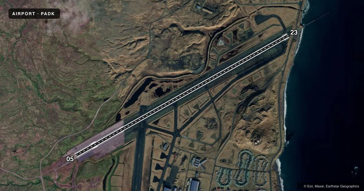
Airport sketch
Runways drawn to scale from FAA survey coordinates, rendered over satellite imagery. Not for navigation.
Approaches & charts
ILS · 1
Services on the field
Fuel grades, oxygen, maintenance, ramp storage and lighting — as declared to the FAA by the airport operator.
Fuel & services
- Fuel
- A1
- Other services
- CARGO
Ramp & ground
- Transient storage
- Not published
- Customs
- Not available
- Lighting schedule
- SEE RMK
- Beacon schedule
- SS-SR
- Beacon
- White / Green (civil land)(WG)
- Wind indicator
- Yes
- Segmented circle
- Yes
Fuel & FBOs
Cheapest 100LL and Jet A on the field and nearby. Always confirm with the FBO before taxi.
Airport notes
Surface conditions, obstructions, local procedures, lighting outages and other notes published with each FAA cycle.
General notes
- VOLCANO 5710 FT MSL 22.3 NM BRG 059 DEGS.
- CTN: EXP WIND SHEAR.
- LOCK BRAKE TURNS NA.
- BIRDS INVOF ARPT.
- PAEW ON RWY.
- AFT HR HAZ RPRTG, SNOW & ICE REMOVAL PPR IN WRITING - AMGR.
- RCMND VISUAL INSP PRIOR TO USE.
- BE ALERT DURG APCH; MT TRRN ALL QUADS.
- ARPT CLSD OCT 01 - APR 30 TO NON SKED ACFT EXC 2 HR PPR - 907-572-9900.
Lighting notes
- ACTVT MALS RWY 23; REIL RWY 23; PAPI RWY 23; HIRL RWY 05/23 - CTAF.
Fuel notes
- A1FUEL SVC 0800-1700 - 907-592-8330. AFT HR PPR; SVC FEE AFT HR - 907-572-6070.
Approach & departure obstructions
- 23NONSTD LEN 600 FT.
- 23UNUSBL BYD 7 DEG RIGHT OF CNTRLN.
Other notes
- ACR OPS MORE THAN 30 PAX SEATS PPR IN WRITING - AMGR P.O. BOX 1952 ADAK AK 99546.
- MANAGERAFTER HRS PHONE NR 907-413-2230.
VFR map & nearby airports
VFR sectional. Tap any ICAO chip to open that airport.
Key facts · PADK
Answer card- ICAO
- PADK
- Name
- ADAK
- Location
- ADAK ISLAND, ALASKA
- Elevation
- 19.5 ft MSL
- Traffic pattern altitude
- 1,019.5 ft MSL (1,000 AGL)
- Control tower
- Non-towered (use CTAF)
- Total runways
- 1
- Longest runway
- 05/23 · 7,790 ft
- Published ILS approaches
- 1
- Published frequencies
- 1
- Magnetic variation
- 7°
- Current flight rules
- MVFR
- Current wind
- 240° at 17 kt
- Favored runway now
- RWY 23
Adak Airport sits on Adak Island in Alaska. Field elevation is 19.5 ft MSL. The airport has one asphalt runway, 05/23, at 7,790 ft. There is no control tower. CTAF is 122.9. The published pattern altitude is not listed, so use the current Chart Supplement before you fly. One ILS approach is published for runway 23.
Aleut Enterprise is on the field. Fuel grades are not reported in the facts provided, so call them directly at (907) 592-8330 for current fuel options and service hours. The remarks also note fuel service from 0800 to 1700. After-hours fuel needs prior permission. A service fee applies after hours. The airport is closed from October 1 through April 30 to non-scheduled aircraft unless prior permission is obtained. There is also a published note about birds in the area. Wind shear is also noted. A volcano sits 22.3 NM away on bearing 059 degrees. That makes local weather and terrain awareness important here. Runway 23 has a nonstandard 600 ft length note. The visual glide slope indicator is unusable beyond 7 degrees right of centerline. Check the current Chart Supplement and call the airport operator or FBO directly before arrival if you need current operating limits or permission.