METAR & TAF NSTU
Current METAR
Observed 16:50Z
NSTU 271650Z 07007KT 10SM SCT022 SCT040 BKN100 24/22 A2981 RMK SLP097 T02400220
- Wind
- 070° @ 7 kt
- Visibility
- 10 SM
- Temp / Dew
- 24°C / 22°C
- Altimeter
- 29.81 inHg
- Clouds
- BKN
- Density alt
- 1,255 ft
- Ceiling
- 10,000 ft AGL
- Rules
- VFR
Airport info & contacts
Manager on record, flight service, ARTCC, attendance schedule and pattern altitude — published by the FAA and refreshed every 28 days.
Location
- From city
- 3 NM SW
- VFR sectional
- GNC 20
- ARTCC
- NZZO · AUCKLAND OCEANIC FIR
- NOTAM facility
- PPG (NOTAM-D)
Airport manager
- Name
- TAVITA S FUIMAONO
- Phone
- 684-733-3154
- Address
- 1539 AIRPORT WAY P.O. BOX 1539, P.O. BOX 1539, PAGO PAGO AS 96799
Flight service · Hours
- FSS HNL
- HONOLULU1-800-WX-BRIEF
- Attendance
- ALL
Frequencies
Tap any row to copy the frequency to your clipboard.
Runways & pattern
Full pagePattern entry · RWY 05
RIGHT TRAFFIC| Runway | Heading (°M) | Length | Surface | Traffic |
|---|---|---|---|---|
| 05/23Favored | 48° / 228° | 10,001 ft | ASPH | 05 R |
| 08/26 | 78° / 258° | 3,801 ft | ASPH | 08 R |
Runway end performance
| End | TORA | TODA | ASDA | LDA | VGSI | Approach lights | Obstruction |
|---|---|---|---|---|---|---|---|
| 05 | 9,200' | 10,000' | 9,200' | 8,200' | PAPI 4-box left(3.25°) | MALSR | 446', hill, 12200' from thr, 1000' R of cntrln, slope 27 |
| 23 | 10,000' | 10,000' | 10,000' | 9,200' | PAPI 4-box left(3°) | — | 8', fence, 300' from thr, slope 12 |
Declared distances in feet. TORA = takeoff run available, TODA = takeoff distance, ASDA = accelerate-stop, LDA = landing distance.
Airport sketch
Runways drawn to scale from FAA survey coordinates, rendered over satellite imagery. Not for navigation.
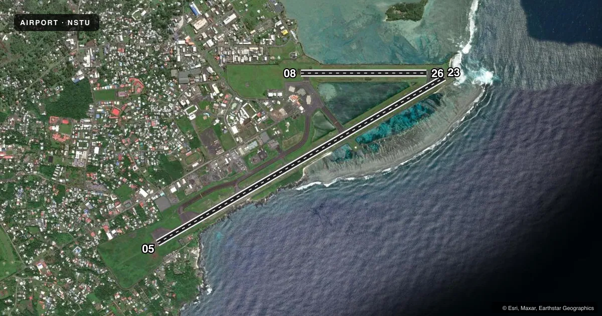
Approaches & charts
ILS · 1
Services on the field
Fuel grades, oxygen, maintenance, ramp storage and lighting — as declared to the FAA by the airport operator.
Fuel & services
- Fuel
- 100A1+
- Oxygen (bottled)
- Not available
- Oxygen (bulk)
- Not available
- Airframe repair
- Not available
- Power plant repair
- Minor
- Other services
- CARGO,CHTR
Ramp & ground
- Transient storage
- Tie-down
- Landing fee
- Yes
- Customs
- Not available
- Lighting schedule
- SEE RMK
- Beacon schedule
- SS-SR
- Beacon
- White / Green (civil land)(WG)
- Wind indicator
- Lighted
- Segmented circle
- Yes
Fuel & FBOs
Cheapest 100LL and Jet A on the field and nearby. Always confirm with the FBO before taxi.
Airport notes
Surface conditions, obstructions, local procedures, lighting outages and other notes published with each FAA cycle.
General notes
- <ALL FLTS (EXCP SKED) PRIOR PMSN FROM AMGR WITH 24 HRS PRIOR NOTICE.
- SEA SPRAY FM SURF & BLOW HOLES MAY DRIFT ACRS RWY 05/23 UNDER ROUGH SEA CONDS.
- ALL ACFT TRANSITING PAGO PAGO (EXCP COMMERCIAL CARRIERS) MUST MAKE FUEL ARRANGEMENTS WITH PPG AT 684-733-3158.
- OLOTELE MT 1617 FT MSL 3.5 MILES WEST OF THLD RY 08.
- PERMLY LGTD & MKD 226' TWR ATOP MT ALAVA 4.3SM NNE ARPT.
- FOR NOTAM CONTACT NEW ZEALAND (643) 358-1688 FSS: NEW ZEALAND
Lighting notes
- DUSK-DAWN. ACTVT MALSR RWY 05; PAPI RWYS 05 & 23; HIRL RWYS 05/23 & 08/26; TWY LGTS FREQ - 118.3.
Runway surface & condition
- 05/23PCR VALUE: 620/F/A/X/T
- 08/26PCR VALUE: 80/F/A/X/T
Approach & departure obstructions
- 08APCH RATIO FOR OLOTELE MTN 11:1.
- 23RY 23 50:1 TO DSPLCD THLD.
Other notes
- LGTD WIND CONE 800' FROM THR & 240' SE RWY 05 CNTRLN.
- MANAGERPHONE NUMBER 685-42530 FALEOLO TOWER FOR IFR 126.9,118.1,118.5
- OWNERPAGO PAGO IS OWNED BY THE AMERICAN SAMOA GOVT AND IS OPERATED BY THE PORT ADMINISTRATION, PORT DIRECTOR, PHONE 684-258-5464.
VFR map & nearby airports
VFR sectional. Tap any ICAO chip to open that airport.
Key facts · NSTU
Answer card- ICAO
- NSTU
- Name
- PAGO PAGO INTL
- Location
- PAGO PAGO, AMERICAN SAMOA
- Elevation
- 31.2 ft MSL
- Traffic pattern altitude
- 1,031.2 ft MSL (1,000 AGL)
- Control tower
- Non-towered (use CTAF)
- Total runways
- 2
- Longest runway
- 05/23 · 10,001 ft
- Published ILS approaches
- 1
- Published frequencies
- 1
- Magnetic variation
- 12°
- Current flight rules
- VFR
- Current wind
- 070° at 7 kt
- Favored runway now
- RWY 05
Pago Pago Intl sits in Pago Pago, American Samoa. Field elevation is 31.2 ft MSL. The airport has 2 asphalt runways. The longest is runway 05/23 at 10,001 ft. Runway 08/26 is 3,801 ft. There is no control tower, so use CTAF 122.9 and keep a sharp scan in the pattern.
One ILS is published for runway 05. Lighting is active from dusk to dawn. Runway 05 has MALSR. PAPI is available on runways 05 and 23. High intensity runway lights are installed on both runways. Pattern altitude is not published. Use the standard 1,000 ft AGL for light piston traffic unless the current Chart Supplement says otherwise. That puts the traffic pattern at about 1,031 ft MSL based on the field elevation.
This is a coastal field, so sea spray can drift across runway 05/23 in rough sea conditions. Olootele Mountain rises to 1,617 ft MSL about 3.5 miles west of runway 08. A lighted and marked 226-foot tower sits on Mount Alava 4.3 statute miles north-northeast of the airport. There is no on-field FBO listed. All flights except scheduled require prior permission from the airport manager with 24 hours prior notice. For NOTAMs, the published contact is New Zealand Flight Service Station. If you need fuel or ramp details, confirm them with the airport operator before departure.