METAR & TAF 52S
52S does not publish a METAR.
Showing the nearest reporting station: KMSO (MISSOULA MONTANA) · 24.5 NM away. Conditions at 52S may differ.
METAR · KMSO
Observed 12:53Z
KMSO 271253Z 12003KT 5SM HZ FU CLR 13/07 A3010 RMK AO2 SLP174 T01280067
- Wind
- 120° @ 3 kt
- Visibility
- 5 SM
- Temp / Dew
- 13°C / 7°C
- Altimeter
- 30.10 inHg
- Clouds
- CLR
- Density alt
- 3,264 ft
- Ceiling
- Unlimited
- Rules
- MVFR
Airport info & contacts
Manager on record, flight service, ARTCC, attendance schedule and pattern altitude — published by the FAA and refreshed every 28 days.
Location
- From city
- 1 NM NE
- VFR sectional
- GREAT FALLS
- ARTCC
- ZLC · SALT LAKE CITY
- NOTAM facility
- GTF (NOTAM-D)
Airport manager
- Name
- RICK NEWMAN
- Phone
- (406) 544-8004
- Address
- 35333 AIRPORT ROAD, ST IGNATIUS MT 59865
Flight service · Hours
- FSS GTF
- GREAT FALLS1-800-WX-BRIEF
- Attendance
- ALL
Frequencies
Tap any row to copy the frequency to your clipboard.
Runways & pattern
Full pagePattern entry · RWY 08
LEFT TRAFFICRunway end performance
| End | TORA | TODA | ASDA | LDA | VGSI | Approach lights | Obstruction |
|---|---|---|---|---|---|---|---|
| 08 | — | — | — | — | — | — | 15', road, 200' from thr, 125' R of cntrln, slope 0 |
| 26 | — | — | — | — | — | — | 12', road, 201' from thr, 120' R of cntrln, slope 0 |
Declared distances in feet. TORA = takeoff run available, TODA = takeoff distance, ASDA = accelerate-stop, LDA = landing distance.
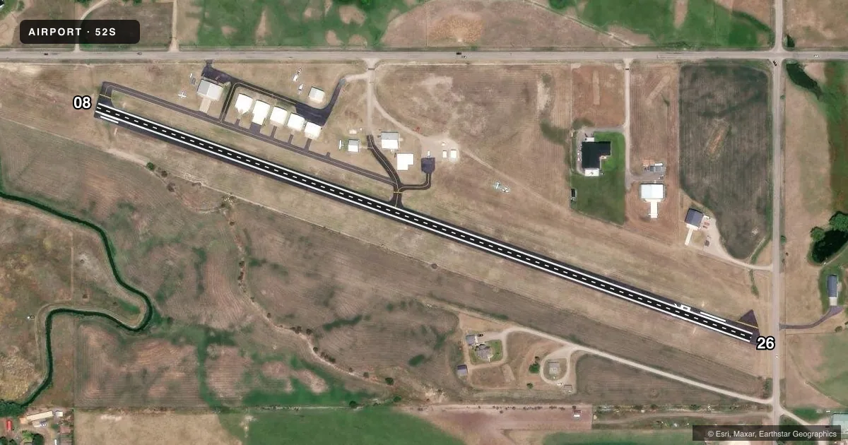
Airport sketch
Runways drawn to scale from FAA survey coordinates, rendered over satellite imagery. Not for navigation.
Approaches & charts
Services on the field
Fuel grades, oxygen, maintenance, ramp storage and lighting — as declared to the FAA by the airport operator.
Fuel & services
- Fuel
- 100LL
- Airframe repair
- Minor
- Power plant repair
- Minor
Ramp & ground
- Transient storage
- Tie-down
- Landing fee
- No fee published
- Lighting schedule
- SEE RMK
- Beacon schedule
- SS-SR
- Beacon
- White / Green (civil land)(WG)
- Wind indicator
- Yes
- Segmented circle
- No
Fuel & FBOs
Cheapest 100LL and Jet A on the field and nearby. Always confirm with the FBO before taxi.
Airport notes
Surface conditions, obstructions, local procedures, lighting outages and other notes published with each FAA cycle.
General notes
- SNOW REMOVAL.
- BIRDS INVOF RWY.
- FOR CD CTC SPOKANE APCH AT 509-742-2522, WHEN APCH CLSD CTC SALT LAKE ARTCC AT 801-320-2568
Lighting notes
- ACTVT LIRL RWY 8/26 - CTAF.
Runway surface & condition
- 08/26100 FT UNLGTD; 2270 FT LGTD AT NGT. RWY 26 240 FT UNLGTD;
Approach & departure obstructions
- 2615 FT N-S ROAD 40-115 FT FM RWY END; 4 FT N-S FENCE 10-90 FT FM RWY END.
- 2618 FT BLDG 200 FT FM RWY END 234 FT R OF CNTRLN; 18 FT BLDG 385 FT FM RWY END 141 FT L OF CNTRLN. TURF OVRN 300X60 FT.
- 08NON STD
- 08CTLG OBSTN EXCEEDS A 45 DEG SLP.
Other notes
- EXISTED PRIOR TO 1959.
VFR map & nearby airports
VFR sectional. Tap any ICAO chip to open that airport.
Key facts · 52S
Answer card- ICAO
- 52S
- Name
- ST IGNATIUS
- Location
- ST IGNATIUS, MONTANA
- Elevation
- 3,006 ft MSL
- Traffic pattern altitude
- 4,006 ft MSL (1,000 AGL)
- Control tower
- Non-towered (use CTAF)
- Total runways
- 1
- Longest runway
- 08/26 · 2,610 ft
- Published ILS approaches
- 0
- Published frequencies
- 1
- Magnetic variation
- 18°
- Current flight rules
- MVFR
- Current wind
- 120° at 3 kt
- Favored runway now
- RWY 08
St Ignatius Airport sits in St Ignatius, Montana. The field elevation is 3,006 ft MSL. It has one runway, 08/26, at 2,610 ft. There is no control tower. CTAF is 122.9. No ILS approaches are published here.
Pattern altitude is not published. Use the standard 1,000 ft AGL for light piston traffic unless the current FAA Chart Supplement says otherwise. That puts the pattern about 4,006 ft MSL. The on-field FBO is St. Ignatius Airport. It carries 100LL. Call ahead at (406) 745-4008 if you need current field details.
A few published remarks matter here. Runway 08 has nonstandard markings. Low intensity runway lights are activated on 08/26 and controlled by CTAF. Night use is not full-length on the runway. The published lighting note says 2,270 ft is lighted at night, with the remaining portions unlighted. There are also obstructions near both ends of runway 26. Birds are reported in the vicinity of the runway. Snow removal is conducted. The field is in a mountain state setting with a 3,006 ft elevation, so performance planning matters on warm days and when density altitude runs up.