METAR & TAF PTRO
Current METAR
Observed 16:50Z
PTRO 261650Z 26008KT 12SM SCT015CB BKN110 BKN290 27/23 A2980 RMK CB ALQDS
- Wind
- 260° @ 8 kt
- Visibility
- 12 SM
- Temp / Dew
- 27°C / 23°C
- Altimeter
- 29.80 inHg
- Clouds
- BKN
- Density alt
- 1,808 ft
- Ceiling
- 11,000 ft AGL
- Rules
- VFR
Airport info & contacts
Manager on record, flight service, ARTCC, attendance schedule and pattern altitude — published by the FAA and refreshed every 28 days.
Location
- From city
- 4 NM NE
- VFR sectional
- GNC 13
- ARTCC
- ZAK · OAKLAND OCEANIC ARTCC
- NOTAM facility
- HNL (NOTAM-D)
Airport manager
- Name
- PETER POLLOI
- Phone
- 680-775-7622
- Address
- P.O. BOX 1471, KOROR, PALAU PW 96940
Flight service · Hours
- FSS HNL
- HONOLULU1-800-WX-BRIEF
- Attendance
- ALL
Frequencies
Tap any row to copy the frequency to your clipboard.
Runways & pattern
Full pagePattern entry · RWY 27
LEFT TRAFFICRunway end performance
| End | TORA | TODA | ASDA | LDA | VGSI | Approach lights | Obstruction |
|---|---|---|---|---|---|---|---|
| 09 | — | — | — | — | PAPI 4-box left(3°) | — | — |
| 27 | — | — | — | — | PAPI 4-box left(3°) | — | 11', trees, 200' from thr, 75' R of cntrln, slope 0 |
Declared distances in feet. TORA = takeoff run available, TODA = takeoff distance, ASDA = accelerate-stop, LDA = landing distance.
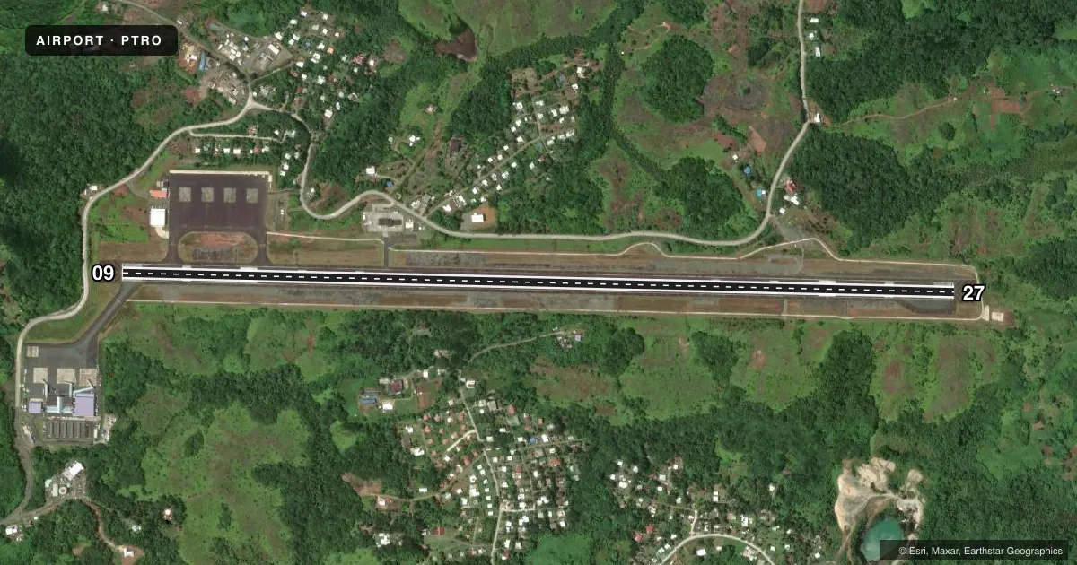
Airport sketch
Runways drawn to scale from FAA survey coordinates, rendered over satellite imagery. Not for navigation.
Approaches & charts
Services on the field
Fuel grades, oxygen, maintenance, ramp storage and lighting — as declared to the FAA by the airport operator.
Fuel & services
- Fuel
- A1
- Oxygen (bottled)
- Not available
- Oxygen (bulk)
- Not available
- Airframe repair
- Not available
- Power plant repair
- Not available
- Other services
- CARGO,CHTR
Ramp & ground
- Transient storage
- Tie-down
- Landing fee
- Yes
- Customs
- Not available
- Lighting schedule
- SEE RMK
- Beacon schedule
- SEE RMK
- Beacon
- White / Green (civil land)(WG)
- Wind indicator
- Lighted
- Segmented circle
- Yes
Fuel & FBOs
Cheapest 100LL and Jet A on the field and nearby. Always confirm with the FBO before taxi.
Airport notes
Surface conditions, obstructions, local procedures, lighting outages and other notes published with each FAA cycle.
General notes
- ALL UNSKED FLTS MUST FILE A FLT PLAN AT LEAST 7 DAYS PRIOR TO ARRIVAL AND ALL FLTS MUST CTC KOROR COMMUNICATIONS ON 123.6 AT LEAST 20 MINUTES PRIOR TO ARRIVAL.
- ARFF AVBL 24/7.
- BE ALERT TO LARGE NUMBER OF BIRDS ON RY AT NIGHT.
- ALL ACFT EXCEEDING 100000 LBS GWT TAXI TO THR TURN AROUND BEFORE TAXING TO APRON. ACFT UNDER 100000 LBS GWT MAY MAKE A TURN AROUND WHERE FEASIBLE.
- ENTRY PERMIT RQRD CALL 011-680-488-2498 FAX 011-680-488-4385; LANDING PERMIT RQRD MUST GIVE SEVEN DAYS NOTICE EMAIL: POLICEPIA@GMAIL.COM; MPIICOFFICE@GMAIL.COM CALL: 680-587-1411;680-587-2182
- (E94) WX STN 5 MI FM ARPT.
Lighting notes
- FOR ROTG BCN CTC KOROR RADIO - 123.6.
- FOR MIRL RWY 09/27 CTC KOROR RADIO - 123.6.
Other notes
- APTS IN TT NOT SUBJ TO FAA REGS, AIRSPACE ANALYSIS NOT RQRD.
- TO CTC HNL FSS CALL LD 808-836-8054. HNL FSS 1-800-WX-BRIEF NUMBER NOT AVBL FM THIS LOCATION.
VFR map & nearby airports
VFR sectional. Tap any ICAO chip to open that airport.
Key facts · PTRO
Answer card- ICAO
- PTRO
- Name
- PALAU INTL
- Location
- BABELTHUAP ISLAND
- Elevation
- 176.5 ft MSL
- Traffic pattern altitude
- 1,176.5 ft MSL (1,000 AGL)
- Control tower
- Non-towered (use CTAF)
- Total runways
- 1
- Longest runway
- 09/27 · 7,200 ft
- Published ILS approaches
- 0
- Published frequencies
- 1
- Magnetic variation
- 1°
- Current flight rules
- VFR
- Current wind
- 260° at 8 kt
- Favored runway now
- RWY 27
Palau Intl sits on Babelthuap Island in Palau. Field elevation is 176.5 ft MSL. The airport has one runway, 09/27, which is 7,200 ft long. There is no control tower. CTAF is 123.6. No ILS approaches are published here.
Pattern altitude is not published. Use 1,000 ft AGL for light piston traffic unless the current Chart Supplement or local procedures say otherwise. The runway headings are 091° and 271° magnetic. That matters when you are lining up in the pattern or checking wind on a crosswind day.
No on-field FBOs are listed in the facts provided. Check with the airport operator or the FBO directly by phone before arrival if you need handling or fuel details. Published remarks also say to contact Honolulu Flight Service Station by landline, since the 1-800-WX-BRIEF number is not available from this location. Unscheduled flights need seven days notice. A flight plan must be filed at least seven days before arrival. You also need to call Koror Communications on 123.6 at least 20 minutes before arrival. Watch for birds on the runway at night. The field also has 24-hour ARFF, which is useful to know if you are planning a late arrival or operating a larger aircraft.