METAR & TAF PAWI
Current METAR
Observed 15:53Z
PAWI 201553Z AUTO 18010KT M01/M03 A2949 RMK AO2 SLP988 T10111033 TSNO
- Wind
- 180° @ 10 kt
- Visibility
- —
- Temp / Dew
- -1°C / -3°C
- Altimeter
- 29.49 inHg
- Clouds
- Clear
- Density alt
- -1,331 ft
- Ceiling
- Unlimited
- Rules
- VFR
Airport info & contacts
Manager on record, flight service, ARTCC, attendance schedule and pattern altitude — published by the FAA and refreshed every 28 days.
Location
- From city
- 1 NM SE
- VFR sectional
- CAPE LISBURNE
- ARTCC
- ZAN · ANCHORAGE
- NOTAM facility
- AWI (NOTAM-D)
Airport manager
- Name
- GEORGE AHMAOGAK
- Phone
- 907-852-0489
- Address
- BOX 69, BARROW AK 99723
Flight service · Hours
- FSS BRW
- BARROW907-852-2511LC852-2511
- Attendance
- Unattended
Frequencies
Tap any row to copy the frequency to your clipboard.
Runways & pattern
Full pagePattern entry · RWY 24
LEFT TRAFFICRunway end performance
| End | TORA | TODA | ASDA | LDA | VGSI | Approach lights | Obstruction |
|---|---|---|---|---|---|---|---|
| 06 | — | — | — | — | PAPI 4-box left(3°) | — | 75', ant, 2320' from thr, 1118' R of cntrln, slope 30 |
| 24 | — | — | — | — | PAPI 4-box right(3°) | — | — |
Declared distances in feet. TORA = takeoff run available, TODA = takeoff distance, ASDA = accelerate-stop, LDA = landing distance.
Airport sketch
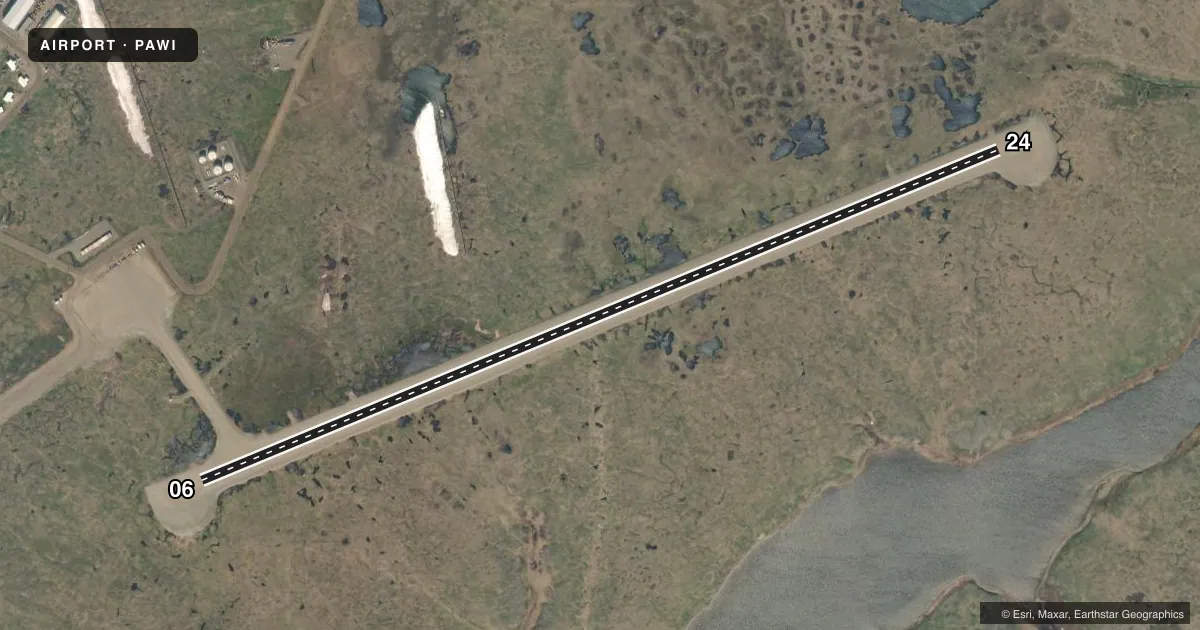
Runways drawn to scale from FAA survey coordinates, rendered over satellite imagery. Not for navigation.
Approaches & charts
Services on the field
Fuel grades, oxygen, maintenance, ramp storage and lighting — as declared to the FAA by the airport operator.
Fuel & services
- Fuel
- Not available
Ramp & ground
- Transient storage
- Not published
- Landing fee
- No fee published
- Customs
- Not available
- Lighting schedule
- SEE RMK
- Beacon schedule
- SS-SR
- Beacon
- White / Green (civil land)(WG)
- Wind indicator
- Lighted
- Segmented circle
- Yes
Fuel & FBOs
Cheapest 100LL and Jet A on the field and nearby. Always confirm with the FBO before taxi.
Airport notes
Surface conditions, obstructions, local procedures, lighting outages and other notes published with each FAA cycle.
General notes
- RWY COND UNMNT; RCMD VISUAL INSP PRIOR TO USE.
- BIRDS ON & INVOF ARPT.
- BARROW FSS - 1-800-779-7709.
- RAMP & TWY SFC SOFT; RUTS & PONDING PSBL.
- WX CAMERA AVBL ON INTERNET AT HTTPS://WEATHERCAMS.FAA.GOV
Lighting notes
- ACTVT REIL RWY 06 & 24; PAPI RWY 06 & 24; MIRL RWY 06/24 - CTAF.
Runway surface & condition
- 06/2440 FT TWR 500 FT N OF RWY.
VFR map & nearby airports
VFR sectional. Tap any ICAO chip to open that airport.
Key facts · PAWI
Answer card- ICAO
- PAWI
- Name
- WAINWRIGHT
- Location
- WAINWRIGHT, ALASKA
- Elevation
- 45.1 ft MSL
- Traffic pattern altitude
- 1,045.1 ft MSL (1,000 AGL)
- Control tower
- Non-towered (use CTAF)
- Total runways
- 1
- Longest runway
- 06/24 · 4,494 ft
- Published ILS approaches
- 0
- Published frequencies
- 1
- Magnetic variation
- 12°
- Current flight rules
- VFR
- Current wind
- 180° at 10 kt
- Favored runway now
- RWY 24
Wainwright Airport sits in Wainwright, Alaska. Field elevation is 45.1 ft MSL. The airport has one runway. Runway 06/24 is 4,494 ft long and gravel. There is no control tower. CTAF is 122.8.
No ILS approaches are published here. Pattern altitude is not published, so use standard light piston pattern planning at 1,000 ft AGL unless current local guidance says otherwise. The runway lighting is pilot-controlled on CTAF. Runway end identifier lights are installed on 06 and 24. Precision approach path indicators are also on both ends.
This is a field where surface condition matters. The Chart Supplement remarks say runway condition is unmonitored. A visual inspection before landing is a good idea. Ramp and taxiway surfaces are soft. Ruts and ponding are possible. Birds are also reported on and near the airport. There is a 40-foot tower 500 feet north of the runway, so keep that in mind on departure and arrival. No on-field FBOs are listed, so verify services with the airport operator or the field directly before you go.